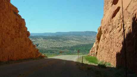
| Despite the high temperatures we elected to drive south briefly
(about 100 miles), in order to quickly look at the Natural Bridges National
Park before heading north. This took us onto a Utah Scenic byway (US95 -
Ancient Trails) from Blanding to Hanksville. This was one of those scenic
gems but nothing prepared us for the view as we cut through a sandstone
ridge. The photo does not do it any justice at all. But this view ranks with
the view of the Rockies we got as we approached Cańon
City from Colorado Springs. |
 |
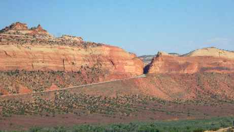 |
Perhaps the view looking back from the other side of the valley can give you
some idea and you can see that this was not any minor cutting we came
through but a significant work of engineering. The problem is that when you
are continuously surrounded by scenery like this you get a bit overloaded. |
| We arrived at Natural Bridges quite late in the day and the
visitor centre was closed. There is a nine mile tour (a one way loop road). It was
with some trepidation that we started on this trip given that our RV is 32ft
long and the carryplatform at the back which carries the scooter is prone to
grounding. However we need not have worried since this road had obviously
been engineered for coach tours. |
 |
 |
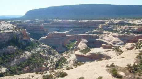
There are three principal stone bridges to see with solid stone arches
towering over deep canyons which had been cut in the soft stone by the
passage of water over the millenia. There is little evidence of the water
flows capable of doing this work but I guess you can get sudden floods here
and it is these which have done the damage. |
| The landscape is deeply fissured and looks more alien than
anything we have ever seen. This is more like a moonscape. It is clear that
the deposits have been made at different times because of the erosion
patterns but our knowledge of geology does not extend to explaining this
beyond saying that different rock strata are exposed in each national park,
hence the different colours of rock and patterns of erosion. But the scale remains the same - VAST. |
 |
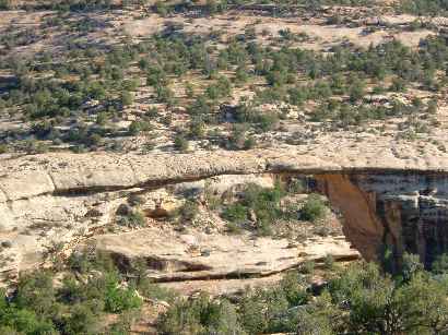 |
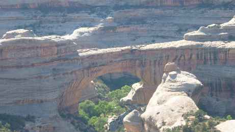
Sometimes you have to look really carefully in order to see the feature you
are looking for. This was the finest (and the largest) of the three bridges
but could easily be missed unless the angles are just right. There was a
three mile hike down to the bottom but we decided it was too late in the day
to sensibly take that option and headed
off to find somewhere to camp. |
| Now this part of the world is not the most populated in the world
and campsites are few and far between. One look at the landscape goes some
way to explaining that. This is a place called Hite at the northern end of Lake
Powell. It was an old uranium mining town which mostly disappeared under the
lake when the river was dammed. What is left is now largely deserted. The
lake is a playground for boats and watersports. It is also huge being over
100 miles long but currently some 50ft below normal level. In this area it is not at
its most attractive. |
 |
 | The
campsite was empty, had no resources and looked uncared for. We camped at
the boat landing (some 500ft from the water) If you look very carefully a
'+' sign marks the spot. I doubt there were 100 people within 100 miles of
us. This was about as remote as it gets (we think!) The scenery is
spectacular - the river at this point is the Colorado which we had camped
beside at Moab the night before. But in this vast arena it seemed lost. |
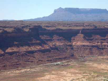
| Just as the cliffs towered above us at the boat landing, so too the
cliffs towered the other side. But we were back in the red sandstones that
we had seen at Arches rather than the white stone of Natural Bridges. |
 |
 | The
unusually high temperatures were causing the mountain snows to melt faster
than normal. The
Colorado is quite wide here and easily absorbed the higher volumes flowing
down itat. Another stream (called the Muddy River) joins it here and it
was living up to its name. |
| The lake disappears off to the south west, silently, several
thousand feet below us as we head towards the Capitol Reef National Park and
yet more colourful canyons and mountains. |
 |
|